The VOR (VHF Omnidirectional Range) Simulator was designed to demonstrate the approximate indication that a VOR would display with varying positions of an aircraft in relation to certain navigational facilities.
VOR Simulator
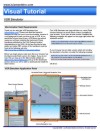
Visual Tutorial |
|
For a detailed explanation of features and instructions please click on the tutorial icon (right) to download and view the VOR Simulator Visual Tutorial (919 KB).
Note: This requires Adobe Acrobat Reader |
|
|
| |
|
|
Condensed Instructions:
Select desired Navaid type and settings. Drag aircraft on horizontal or vertical panels to change the aircraft's position in relation to the facility. If North Up is selected aircraft heading changes can be set by positioning the cursor close to the aircraft on the horizontal panel then clicking the button when a "-" or "+" appears. If Heading Up is selected, aircraft heading changes can be set by positioning the cursor close to the navigational facility on the horizontal panel then clicking the button when a "-" or "+" appears.
When Heading Up is selected, even though it may seem that the aircraft rotates around the navigational facility, the aircraft remains in the same position when changing heading. The reason for this is that the display will always show the navigational facility in the center of the display. This means that regardless if North Up or Heading Up is selected the aircrafts position will always be relative to the navigational facility.
General Explanation of Features:
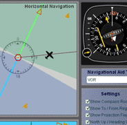
Compass Rose - Used as an aid to show the orientation of the Horizontal Navigation panel. It serves the same purpose
as the compass rose symbol on IFR enroute charts to show direction in relation to the magnetic north.
To / From Region - Shows on the Horizontal Navigation panel the regions where the VOR flag will display
To or From depending on where the aircraft is positioned.
Projection Flags - IFR approach plates have a profile view that displays the sideways vertical projection of the approach
course. The projection flags serve to help visualize how and where this projection is made from the Horizontal Panel
view. Notice how the aircraft moves on the Horizontal panel when it is dragged on the Vertical panel and vice
versa. The movement is made in alignment with the projection flags.
Horizontal Panel - Displays the horizontal position of the aircraft in relation to the navigational facility the same
way an IFR enroute chart or an approach plate's plan view would.
Vertical Panel - Displays the vertical position of the aircraft in relation to the navigational facility the same
way an approach plate's profile view would. It is used for several purposes:
1. For the glide slope feature.
2. Higher altitudes increase the diameter of the cone of confusion (zone above and around the VOR facility where
the VOR receiver does not work properly and will typically display a red NAV flag) .
3. The DME measures slant range distance from the aircraft to the facility. Being able to control the altitude allows
you to determine its influence and consequently the error associated to it.
Navigation Aid Type - Selects the type of navigational facility. Some features such as DME or glide slope will only work
with certain types of facilities.
Settings Section - Select and activate different features.
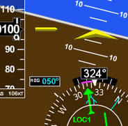
Information Section - Displays information such as heading, altitude, DME distance and OBS setting. (This section
cannot be changed by the user).
*Please note that DME may not be present together with localizer, back course localizer, LDA or SDA approaches. The DME distance shown is the approximate value a DME would indicate if such navigational facility were collocated.
CAUTION: The behavior of the VOR and other information displayed is approximate for illustration purposes only and may not reflect the actual readings on the VOR and DME.
RELATED WEBSITES:
Dave Ropers' Website (Interesting Article on VOR Navigation)
Link to interesting article on VOR navigation
Campbells.org
(A personal website of Joe Campbell and his family and includes very insightful articles on several aviation topics)
Link to another interesting Article on VORs and VOR navigation