The Altimeter Errors Simulator allows you to estimate the errors caused by changes in pressure and temperature if the aircraft's altimeter remained with the same altimeter setting throughout the change; in addition to the pilot maintaining the original indicated altitude throughout.
Important Note: Because you are flying Indicated Altitude on both left and right scenarios, THE TWO LEFT AND RIGHT ALTIMETERS WILL INDICATE THE SAME ALTITUDE–this is deliberate–not a bug.
Altimeter Errors
Simulator
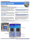
ALTIMETER ERRORS SIMULATOR VISUAL TUTORIAL
For a detailed explanation of features and instructions please click on the tutorial icon (right) to download and view the Altimeter Errors Simulator Visual Tutorial (437 KB).
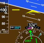
In the left column enter the indicated altitude and the current altimeter setting that the pilot is flying. The simulator will then assume that your true altitude will be the same as your indicated altitude and will calculate but not display the temperature that this would occur*. Next, in the right column, assume that the conditions of temperature and pressure have changed while the pilot is flying, but the pilot has not entered the new altimeter setting and has not taken in account the temperature change. Enter the new correct altimeter setting (which the pilot has not entered in his altimeter) and the temperature change. The simulator will estimate the true altitude that the aircraft is really flying and display it in the right column. Notice that if you fly from an area of higher pressure to lower and/or fly from an area that is warmer to a cooler one, the true altitude will be lower than what is shown in the altimeter. Hence the saying: "From high to low, hot to cold, look out below".
As mentioned in the introduction note, It is also important to remeber that the altimeters on the left and right side will always indicate the same. The reason there are two is that I wanted to show each situation and condition on each side (scenarios 1 through 2). In this case the pilot is flying a constant indicated altitude on his altimeter therefore both altimeters indicate the same. Yet the aircraft as shown above may actually be at a different altitude (true) than indicated when conditions such as pressure and temperature change. I admit this can cause confusion since you may expect to have some change on the second altimeter. This is not an error with the simulation.
*Please note though that in practice altimeters are only adjusted for pressure but not temperature, so the condition in which indicated altitude equals true altitude only occurs at the airport elevation in which the altimeter setting is obtained.
Note:
This site has been optimized for PC and laptop use. Due to lack of physical keyboard and mouse pointer; or because of the smaller screens, may not be usable on tablets and smart phones. Hasn't been tested on iPads with keyboard and mouse pad. Uses Ruffle Flash emulator.
IF YOU RECEIVE AN ERROR MESSAGE FROM YOUR BROWSER, REFRESHING THE PAGE USUALLY RESOLVES IT.
Navigation Simulator
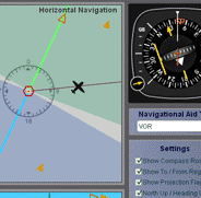
Check out our online version that runs directly on this website, and can be viewed on a Windows PC, Mac, or Linux OS. Practice in this simulator specifically designed for learning the basics of instrument navigation.
There is also the traditional Navigation Simulator that runs on PC Windows as a standalone app. Try the Navigation Simulatorfor for PC. Now completely free — forever!.
A Multitude of Other
Online Simulators
No installation required. These simulators are ready to run on your web browser and have a rich set of features. Practice basic VOR, ADF, RMI and HSI intrument orientation and execute holding patterns. Other simulators include pitot static system and altimeter errors. Click here to go to main online simulator page.
By Luiz Roberto Monteiro de Oliveira. Screenshots and video captures allowed (personal, business or military)
as long as credited to author and link to this site or URL included. Permission required for all other uses.